- 516 Update
- Posts
- Waterfalls on Long Island: Hidden Cascades, Park Spillways & Scenic Spots to Explore
Waterfalls on Long Island: Hidden Cascades, Park Spillways & Scenic Spots to Explore
Discover waterfalls on long island with 7 hidden cascades, scenic spots, and park spillways - your ultimate guide to natural beauty.
516 Update
December 18, 2025

Long Island’s famously flat topography means true waterfalls on Long Island are rare. Yet Nassau County, NY and neighboring Suffolk County hide charming cascades, spillways and landscaped falls in parks and preserves. From a gentle waterfall at Muttontown Preserve in East Norwich to the historic spillway on the Upper Carmans River in Yaphank, these seven spots offer photo-worthy views, easy trails and community value for families, young professionals and active retirees alike. Read on for trail details, parking tips and why each waterfall-like feature matters to local residents—and be sure to subscribe or visit our events page for guided hikes and seasonal outings.
1. Muttontown Preserve Waterfall – East Norwich
Nestled near Jericho Turnpike in East Norwich, the Muttontown Preserve Waterfall is a small man-made cascade along the preserve’s walking trails. Though only 3–4 feet tall, the tumbling water over stone ledges creates a peaceful woodland scene perfect for a short escape.
What You’ll See
A gentle flow over stacked stones, framed by oak and hickory woods
Moss and ferns thriving on damp, shaded banks
A clear plunge pool ideal for macro photography
Trail & Accessibility
Location: Off Jericho Turnpike, near Oyster Bay Road
Parking: Free lot at the main entrance; no permit required
Difficulty: Easy – 0.5-mile loop on compacted dirt
Accessibility: Not ADA-compliant; trail can be muddy after rain
Photo-Friendly Features
Long exposures on overcast days for silky water effects
Close-ups of mossy rocks with soft dappled light
Wide shots showing the cascade against autumn foliage
Nearby Amenities & Tips
Picnic tables and restrooms at the trailhead
Combine with a visit to Muttontown’s historic playground
Bring insect repellent in late spring and summer
2. Sands Point Preserve Waterfall – Sands Point
At the tip of the Cow Neck Peninsula in Sands Point Preserve, you’ll find a landscaped waterfall nestled along manicured gardens and woodlands. This romantic feature is a favorite for local photographers and a quick stop for families visiting Port Washington.
What You’ll See
A tiered waterfall flowing into a stone basin
Decorative plantings, stone bridges and benches for viewing
An elegant stone pavilion nearby, often used for events
Trail & Accessibility
Location: Shore Road, Sands Point
Parking: Designated lot at the Gulf Gate; small fee or NY State Parks pass
Difficulty: Very easy – paved paths and garden sidewalks
Accessibility: ADA-compliant throughout the main garden area
Photo-Friendly Features
Golden hour shots illuminating the falls and pavilion
Reflections in the still pool before the cascade
Framing the waterfall with seasonal flower beds
Nearby Amenities & Tips
Café at the Vanderbilt Mansion Visitor Center
Restrooms, picnic tables and interpretive signage
Check for seasonal concerts and garden tours on weekends
3. Avalon Park & Preserve Waterfall – Stony Brook
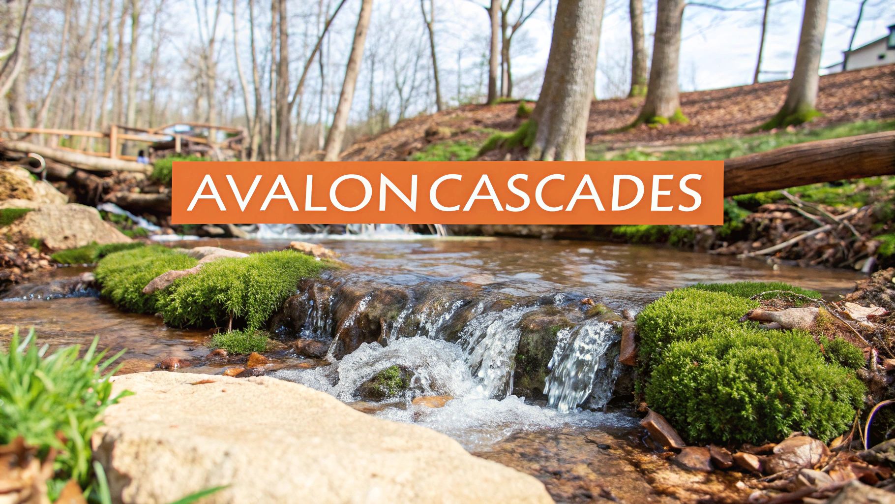
This handcrafted waterfall at Avalon Park & Preserve emerges along a winding boardwalk in Stony Brook. Fed by natural springs, the 5–6 small cascades tumble over glacial bedrock, creating a serene woodland oasis just off Route 25A.
What You’ll See
Multiple drops of clear, spring-fed water over smooth rock
Lush beech and maple forest framing each cascade
Occasional wildlife sightings—herons and wood ducks patrol the stream
Trail & Accessibility
Location: Near Stony Brook University entrance, off Route 25A
Parking: Main lot by the gatehouse; limited spaces on busy days
Difficulty: Easy–moderate – 1.5-mile loop with uneven boardwalk sections
Accessibility: Partial ADA – boardwalks are stroller-friendly, but some roots and mud
Photo-Friendly Features
Slow-shutter shots of silky water on cloudy afternoons
Macro frames of fresh green moss and fern tips
Elevated views from the upper boardwalk segments
Nearby Amenities & Tips
Restrooms and water fountains at the visitor center
Picnic tables and benches at trail junctions
Download trail map in advance; signage can be sparse
4. Blydenburgh County Park Spillway – Smithtown
At the headwaters of the Nissequogue River in Smithtown, the spillway at Blydenburgh County Park is a photographer’s favorite. When the dam releases water, a 4-5 foot cascade forms over a stone channel, framed by grassy meadows and forested banks.
What You’ll See
A broad, low spillway pouring into a shallow pool
Riverbank wildflowers, cattails and maples in season
Interpretive signage about the park’s mill history
Trail & Accessibility
Location: Blydenburgh Road West, Smithtown
Parking: Large lot near the picnic grove; no fee on weekdays
Difficulty: Easy – 1-mile loop on mixed gravel and dirt
Accessibility: Partially ADA – paved near parking, then moderate terrain
Photo-Friendly Features
Panoramic shots of the spillway with rising mist
Reflections in the calm pool before water drops
Wide-angle compositions including meadow and forest
Nearby Amenities & Tips
Picnic shelters, grills and restrooms adjacent to spillway
Kayak rental and fishing access along the river
Check dam release schedule online for optimal flow
5. Argyle Lake Cascade – Babylon Village
On Argyle Lake’s south end in Babylon Village, a stone spillway creates a charming 6-foot drop into a lily-lined pool. This easy-access cascade is perfect for commuters stopping off Babylon Road or families visiting nearby playgrounds.
What You’ll See
Tightly stacked stone ledges forming a neat waterfall
Water lilies, cattails and dragonflies dancing in the shallows
A gentle rippling soundscape ideal for relaxation
Trail & Accessibility
Location: Argyle Lake Park, off Argyle Lake Road
Parking: Free lot by the playground; no permit needed
Difficulty: Very easy – paved 0.3-mile loop
Accessibility: Fully ADA-compliant boardwalk section
Photo-Friendly Features
Wide shots capturing the full width of the spillway
Close-ups of water trailing over mossy stones
Reflection shots of reeds and sky in mirror-calm pool
Nearby Amenities & Tips
Children’s playground, restrooms and picnic tables on site
Bike racks for riders exploring nearby Babylon trails
Visit early summer for lily blooms and active birdlife
6. Massapequa Preserve Cascades – Massapequa
Within Massapequa Preserve’s 450 acres, multiple small cascades and stream flows meander through cattail marshes and upland forest. Near Merrick Road you’ll find short side trails that lead to these water features—ideal for a quick photo op or family nature walk.
What You’ll See
Series of 1–2 foot drops over natural rock in a shaded creek
Marsh grasses, hardy cattails and seasonal wildflowers
Painted turtles basking on logs in slow pools
Trail & Accessibility
Location: Merrick Road entrance, Massapequa Preserve
Parking: Municipal lot; free but fills by midday on Saturdays
Difficulty: Easy – 0.7-mile out-and-back on woodchip trails
Accessibility: Not ADA; boardwalk sections cross marshes only
Photo-Friendly Features
Macro shots of water droplets on reeds
Framing cascades with yellow marsh flags in late summer
Slow-shutter exposures under diffuse light
Nearby Amenities & Tips
Picnic area and benches near the main parking
Combine with a visit to nearby Massapequa Farmers Market
Wear waterproof footwear after heavy rain
7. Upper Carmans River Spillway – Yaphank
The historic mill spillway on the Upper Carmans River in Yaphank forms a 6-8 foot waterfall-like drop over weathered stone. This spillway is one of the most accessible Long Island waterfalls for history buffs, birdwatchers and families seeking a quiet riverside picnic.
What You’ll See
A continuous flow over old dam stone, framed by sycamore and oak
Ferns and moss thriving on damp downstream rocks
Remnants of 19th-century mill machinery along the bank
Trail & Accessibility
Location: Off North Main Street, Yaphank
Parking: Small pull-off on Weeden Road; arrive early on weekends
Difficulty: Easy – 0.5-mile out-and-back on flat dirt track
Accessibility: Not ADA; watch for mud near water’s edge
Photo-Friendly Features
Long exposures under soft light for silky water
Wide compositions including mill ruins and canopy
Close-ups of lichen and water patterns on stones
Nearby Amenities & Tips
Restrooms and picnic tables at Yaphank Community Park (0.7 miles)
Pack sandwiches for a riverside lunch
Download Suffolk County Parks map before you go
Best Times to Visit
Spring (April–June) when rainfall and snowmelt boost flow
After heavy rain for stronger cascades
Early mornings or weekdays to avoid crowds in Nassau County and Suffolk County parks
Late autumn for colorful foliage contrasts
Tips for Exploring Long Island Waterfalls
Safety: Wear sturdy, waterproof shoes to navigate slippery rocks
Trail Etiquette: Stay on marked paths and carry out all trash
Gear: Bring a lightweight tripod and polarizing filter for clear water shots
Wildlife: Carry binoculars for birdwatching along creek corridors
Permits: Check park pass requirements at Sands Point and county preserves
These seven waterfall-like features—spanning East Norwich, Sands Point, Stony Brook, Smithtown, Babylon Village, Massapequa and Yaphank—offer some of the best waterfall hikes Long Island residents can enjoy without leaving the region. Whether you’re planning a family outing from Garden City, a solo photo mission from Levittown, or a weekend nature break after work in Mineola, these local gems deliver scenic value and easy access.
Call to Action: Subscribe to 516 Update for hyperlocal guides on waterfalls on Long Island and community events near you, or visit our events page to sign up for guided waterfall walks, nature festivals and outdoor meetups across Nassau County and Suffolk County.