- 516 Update
- Posts
- Your Guide to Nassau County's 7 Key LIE Expressway Exits Types for 2026
Your Guide to Nassau County's 7 Key LIE Expressway Exits Types for 2026
Your complete guide to the 7 types of LIE expressway exits in Nassau County, NY. Learn how to navigate local interchanges and beat traffic.
516 Update
February 02, 2026

If you're a Nassau County resident, you know the Long Island Expressway is a central part of daily life. It connects vibrant communities like Mineola, Levittown, and Garden City, but navigating its exits can be frustrating, especially with confusing interchanges or unexpected traffic near Roosevelt Field. This guide offers actionable information to help you understand the different types of LIE expressway exits you'll encounter in Nassau County, NY. Knowing the design of an exit can make your commute safer and less stressful.
This guide is your resource for mastering the LIE's interchanges. We’ll break down each major exit type, from the simple diamond ramps in Roslyn to the complex cloverleafs near major commercial hubs. For each, we'll explain why it's there and how to navigate it, whether you're heading to a business meeting in Hempstead or a park in Jericho. By understanding these designs, you can anticipate traffic, choose better routes, and drive with confidence. Ready for a smoother journey? Let's begin. For more local guides and weekend event calendars, be sure to visit our events page and subscribe for updates.
1. Diamond Interchange
The diamond interchange is the most common design for Long Island Expressway exits in Nassau County, serving as the primary connection to local roads. Its simple layout features a four-way intersection on the surface street directly below the LIE overpass. Two sets of on-ramps and off-ramps create a diamond shape, allowing for a straightforward transition from the highway to our local towns. This matters to residents because it's the design we encounter most frequently, guiding us into the heart of our communities.
This efficient configuration allows for relatively seamless moves between high-speed highway traffic and local suburban streets. For Nassau County drivers, this is the most familiar type of exit, guiding commuters, families, and visitors into the heart of our communities.
Why It's Common in Nassau County
The diamond interchange’s prevalence in Nassau County is due to its cost-effectiveness and smaller footprint. This made it an ideal choice as the LIE was built through developing suburban areas. It efficiently serves moderate traffic volumes, which is typical for exits leading into towns like Roslyn Heights or Albertson rather than connecting to other major highways. Infrastructure projects often focus on improving these existing interchanges, as seen in various local upgrades. For more on how local infrastructure is evolving, you can read about the $1.4 million overhaul planned for Shore Road, a project aimed at improving community connections.
Several key LIE expressway exits in Nassau County use this design, each with unique traffic patterns.
Exit 37 (Willis Avenue): A critical artery serving Roslyn Heights, Albertson, and Mineola. This exit is a gateway to the Northern State Parkway and is notoriously congested during rush hour due to its proximity to the Mineola LIRR station and local business districts.
Exit 39 (Glen Cove Road): This interchange funnels traffic toward the villages of Old Westbury, East Hills, and Roslyn Harbor. It’s a key access point for NYIT and SUNY Old Westbury, so expect traffic surges that align with the academic calendar.
Actionable Tips for Drivers
To navigate these busy intersections smoothly, especially if you're a commuter or heading to a school event, keep these strategies in mind:
Anticipate Left Turns: At exits like Willis Avenue, the left-turn lanes from the off-ramp onto the surface street are often the primary source of backups. It's crucial to get into the correct lane well before the traffic light.
Know Peak Congestion Times: Beyond the standard 7-9 AM and 4-6 PM rush, be mindful of local event traffic. An evening concert at the Tilles Center near Exit 39 or an event in Westbury can add significant delays.
Plan Alternate Routes: If you see heavy backup on your navigation app for a diamond exit, consider using the one before or after it. For example, if Exit 37 is jammed, using Exit 36 (Searingtown Road) and cutting across local streets can sometimes be faster.
2. Trumpet Interchange
The trumpet interchange is a more specialized design for Long Island Expressway exits, used where the expressway terminates at or connects with another major road, like a parkway. Its distinct "trumpet" shape uses one loop ramp and several directional ramps to facilitate smoother, higher-speed transitions without the stop-and-go of a typical intersection. For Nassau County drivers, these interchanges often signify a major transition point, guiding traffic from the LIE onto routes leading to North Shore communities or other key destinations.
This asymmetrical layout is particularly effective for connecting the LIE to significant north-south arteries or another parkway. For Nassau County drivers, these interchanges often signify a major transition point, guiding traffic from the expressway onto routes that lead to the North Shore's waterfront communities or business hubs.
Why It's Found in Nassau County
The trumpet interchange's design is ideal for T-intersections where one highway ends at another, making it a perfect solution for connecting the LIE with other major parkways in Nassau County, NY. Its ability to handle directional traffic flow without conflicting left turns makes it safer and more efficient than a diamond interchange for these specific connection points. This design was crucial in linking the east-west flow of the LIE with Nassau's vital north-south parkways and routes that were already established or planned.
Several key LIE expressway exits in Nassau County use a variation of the trumpet design to manage complex traffic flows, especially when connecting to other major parkways.
Exit 38 (Northern State Parkway): This is a classic example where the LIE meets another major highway. The interchange allows for seamless transitions between the two parkways, a critical function for commuters traveling between Nassau and Queens or heading toward the North Shore.
Exit 41 (NY-106/NY-107): Connecting drivers to Oyster Bay, Hicksville, and Bethpage, this interchange manages the convergence of two major state routes with the expressway. It's a key access point for business districts and the Hicksville LIRR station.
Actionable Tips for Drivers
To navigate these interchanges safely, especially if you're commuting or heading to Oyster Bay for a day trip, keep these strategies in mind:
Study Signage in Advance: Trumpet interchanges can have confusing splits. Pay close attention to overhead signs to ensure you're in the correct lane for the Northern State Parkway East vs. West, for example. Missing your turn can lead to a lengthy detour.
Be Cautious of Loop Ramp Speeds: The looped on-ramps require a significant reduction in speed. Be prepared to slow down quickly as you enter the loop and then accelerate sharply to merge with high-speed parkway traffic.
Use GPS for Lane Guidance: Modern navigation apps like Waze or Google Maps provide excellent lane guidance. Use them to visualize the interchange's layout before you arrive, which is especially helpful for less-experienced drivers.
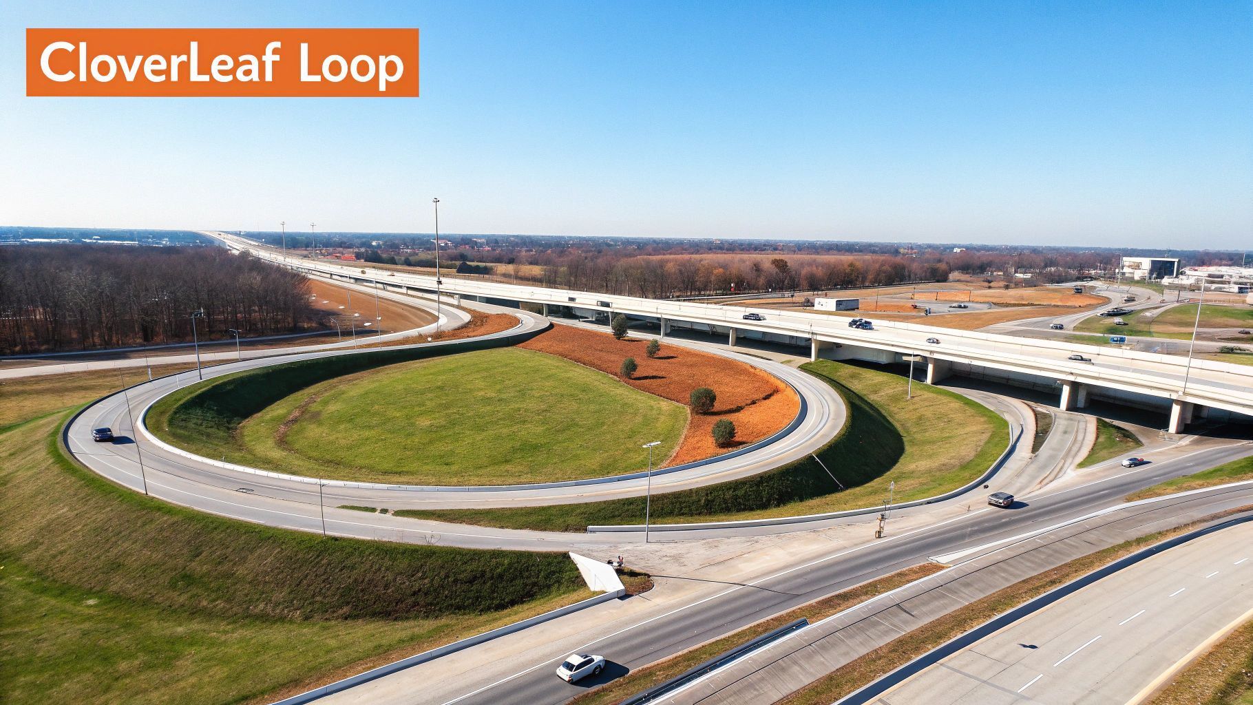
3. Cloverleaf Interchange
The cloverleaf interchange is a classic highway design featuring four loop ramps that allow traffic to change directions between two major expressways without stopping. While newer, more compact designs are now favored, these large-scale interchanges remain critical parts of our road network in Nassau County. For local drivers, navigating these sprawling junctions, like the one connecting the LIE to the Seaford-Oyster Bay Expressway, is a daily reality that requires focus and an understanding of its unique traffic dynamics.
These interchanges were designed to facilitate a continuous, free-flowing movement of vehicles between two high-speed roadways. For Nassau County drivers, navigating these sprawling junctions, like the one connecting the LIE to the Seaford-Oyster Bay Expressway, is a daily reality that requires focus and an understanding of its unique traffic dynamics.
Why It's Common in Nassau County
The cloverleaf’s presence in Nassau County is a legacy of the post-war boom when the LIE and other parkways were built across what was then largely undeveloped land. Its large footprint was less of a concern, and the design was effective for connecting major arteries. While full cloverleafs are rare, hybrid designs are common at major Long Island Expressway exits where north-south parkways intersect the east-west LIE. As Nassau County invests in infrastructure, the focus is often on improving these existing, vital junctions.
These interchanges are major transition points, each handling immense traffic volumes and serving as gateways to different parts of Nassau County.
Exit 44 (Seaford-Oyster Bay Expressway / NY-135): This is a massive interchange connecting the LIE to a key north-south route. It serves Plainview, Syosset, and Woodbury, and is a primary route for commuters heading to Jones Beach or the business corridors in Melville. The "weaving" required between entering and exiting traffic on the loop ramps is a major cause of congestion here.
Exit 40 (NY-25 / Jericho Turnpike): This is a hybrid interchange in Jericho. While not a full cloverleaf, it incorporates loop ramps to handle the heavy traffic flow between the LIE and one of Long Island's most significant commercial roads, serving Jericho, Syosset, and Westbury.
Actionable Tips for Drivers
Navigating a cloverleaf requires more planning than a simple diamond exit, especially for commuters or families heading to local landmarks like Old Westbury Gardens.
Mind Your Speed on Loops: The loop ramps have significantly lower posted speed limits for a reason. Adhere to them strictly to maintain control, especially in wet or icy conditions.
Avoid Weaving Areas: "Weaving" occurs where traffic entering the highway from a loop ramp must cross paths with traffic exiting onto the next loop. This is a common bottleneck. If you are traveling straight through, stay in the center or left lanes to avoid this conflict zone.
Anticipate Heavy Merging: Traffic entering the LIE from a cloverleaf ramp often does so at a lower speed. Be prepared for slow-moving vehicles merging ahead of you, and give them space.
Know Your Exit in Advance: These interchanges are large and can be confusing. Know whether you need to exit before or after the main junction and position yourself in the correct lane well in advance.
4. Directional Ramp Interchange
The directional ramp interchange is a modern design engineered to handle high volumes of traffic between major roadways like the LIE and other parkways. These Long Island Expressway exits feature grade-separated ramps that curve in the general direction of travel, allowing vehicles to change highways at higher speeds without the weaving that causes bottlenecks in older designs. For Nassau County commuters traveling between major employment hubs, these interchanges are designed to minimize slowdowns and provide a more efficient connection.
This modern design is crucial for managing the flow between the LIE and other major arteries like the Northern State Parkway or Meadowbrook Parkway. For Nassau County commuters traveling between major employment hubs in areas like Great Neck, Hempstead, and Long Beach, these interchanges are engineered to minimize slowdowns and provide a more efficient, less stressful connection.
Why It's Key for Major Nassau Corridors
Directional ramp interchanges are expensive and require a large footprint, so they are reserved for the most critical, high-volume junctions in Nassau County. Their purpose is to move large amounts of traffic from one major highway to another with minimal speed reduction. As our county's traffic density has grown, modernizing key junctions with these designs has become a priority for improving regional traffic flow. You can learn more about how the county is tackling traffic by reading about Nassau County's spring alert and traffic solutions.
These interchanges are the giants of the LIE system, connecting thousands of drivers to other vital parkways and expressways in Nassau County.
Exits 31A & 38 (Northern State Parkway): The interchanges connecting the LIE to the Northern State Parkway are prime examples of directional design. These connections are vital for commuters heading toward Queens or deeper into Suffolk County.
Exit 31S (Cross Island Parkway): Serving as a major gateway from Nassau County to Queens and the bridges to the Bronx, this interchange uses directional ramps to funnel traffic southward efficiently.
Actionable Tips for Drivers
While these interchanges are designed for efficiency, they require attention and forward planning, whether you're commuting into the city or heading out for a weekend trip.
Maintain Highway Speed: The ramps are built for higher speeds than those at diamond or cloverleaf interchanges. Be prepared to merge with traffic that is also moving quickly.
Know Your Lane Early: These are complex systems. Signage appears well in advance, so identify which highway you are connecting to and move into the correct lane at least a mile before the exit to avoid dangerous last-minute maneuvers.
Be Aware of Construction: Because these interchanges are so critical, they are often the sites of major upgrade projects. Always check for lane closures or new traffic patterns before a long commute, especially if you're heading toward a major hub like Hempstead.
5. Parclo (Partial Cloverleaf) Interchange
The Parclo, or partial cloverleaf interchange, is a hybrid design that blends the efficiency of a diamond interchange with the free-flowing loops of a cloverleaf. This smart configuration is one of the more sophisticated LIE expressway exits you'll find in Nassau County, designed to handle higher traffic volumes without the massive land requirement of a full cloverleaf. It typically features two loop ramps to handle left turns more safely, minimizing dangerous crossings of oncoming traffic.
This design is strategically placed where a simple diamond would be overwhelmed but a full cloverleaf is unnecessary. For Nassau County drivers, a Parclo often signals a transition to a significant local artery or a denser commercial area, facilitating smoother movement from the high-speed expressway into bustling community centers.
Why It's Used in Key Nassau County Corridors
The Parclo interchange is a problem-solver for Nassau County's infrastructure. It was often implemented in areas like Jericho and Hicksville where traffic projections showed a need for something more robust than a diamond interchange. This design excels at moving large volumes of traffic off the expressway and onto surface streets more safely by eliminating some of the most conflict-prone left turns. It's the go-to choice for exits serving a mix of residential, commercial, and commuter traffic.
While not as common as the diamond, Parclos are critical choke points in the Nassau road network. Understanding their layout can save you time and stress.
Exit 41 (Route 106/107): A major junction for Jericho and Hicksville, this Parclo manages traffic heading toward Broadway Commons (formerly Broadway Mall) and numerous corporate offices. The loop ramps can get congested, especially during evening rush hour and weekend shopping peaks.
Exit 44 (Route 135 Seaford-Oyster Bay Expressway): This interchange is a crucial connection for commuters traveling between the North and South Shores. The design efficiently funnels traffic onto another major expressway, but the merging and weaving required demand driver attention.
Actionable Tips for Drivers
Navigating a Parclo smoothly is all about lane discipline and anticipating your moves. Whether you're a commuter from Levittown or a parent heading to a sports complex in Garden City, these tips will help.
Study the Signage: Parclo exits require you to know your next move earlier than diamond exits. Pay close attention to overhead signs to ensure you're in the correct lane for either a loop ramp (usually a right-hand exit to make a left turn) or a direct ramp.
Minimize Loop Ramps at Peak Times: The loop ramps are where bottlenecks form. If your navigation app shows heavy delays on a loop, consider taking the exit before or after and using local roads to bypass the congested turn.
Watch for Weaving Traffic: The point where traffic from a loop ramp merges onto the surface street can be a conflict zone. Be cautious and ready to adjust your speed.
Use Outer Lanes for Through Traffic: If you are on the surface street and just passing through the interchange area, stay in the outermost lanes to avoid getting caught up in the exiting and entering traffic flows.
6. Exit Ramp with Frontage Road
The frontage road, often called a service road, is a key component of many Long Island Expressway exits, especially in commercially dense areas of Nassau County like Plainview and Jericho. This design features dedicated exit ramps that lead onto a parallel road running alongside the LIE. This separates high-speed through-traffic from local traffic seeking access to businesses and offices. This matters to residents because it reduces congestion on the expressway and makes accessing local businesses safer and easier.
This configuration is a game-changer for reducing congestion on the expressway itself. By allowing drivers to exit early and travel along the service road to their specific destination, it prevents the constant merging and weaving that can cause significant backups. For Nassau County residents, these frontage roads are the gateways to major shopping centers and business districts, making daily errands and commutes more manageable.

Why It's Common in Nassau County
The frontage road design is particularly effective in built-up commercial corridors where numerous businesses require direct, safe access. As areas like East Meadow and Mineola developed, placing dozens of driveways directly onto a main road became impractical and dangerous. Frontage roads provide a controlled, lower-speed environment for vehicles to enter and exit parking lots, serving everything from large retail centers to local restaurants and corporate parks. The ongoing focus on improving traffic flow is evident in many local infrastructure projects. For example, understanding how ramp upgrades improve local access is crucial, as seen in the plans for the $6.8M Valley Stream parkway ramp upgrade.
Many LIE expressway exits in Nassau County use frontage roads to manage access to bustling commercial zones.
Exit 40 (NY 25/Jericho Turnpike): The service roads here are essential for accessing Jericho and Syosset's corporate offices and shopping plazas without congesting the main highway.
Exit 41 (NY 106/107): This exit's service roads distribute traffic heading towards the Broadway Commons mall and the dense commercial areas along North Broadway in Hicksville.
Exits 43-44 (South Oyster Bay Rd/NY 135): The extensive frontage road system here serves a massive commercial area, including office parks and retail strips in Plainview and Syosset.
Actionable Tips for Drivers
For shoppers, commuters, or anyone running errands, using frontage roads effectively can save time and reduce stress.
Exit Early for Local Trips: If your destination is a specific store along a commercial strip, exit onto the service road as soon as possible. This avoids having to battle expressway traffic only to double back.
Use Them as a Bypass: During peak LIE congestion, the frontage road can sometimes serve as a short-term bypass. It can keep you moving toward the next on-ramp while the main lanes are at a standstill.
Mind the Entrances and Exits: Be highly aware of other vehicles merging onto the service road from the LIE and from business parking lots. Traffic flow is more complex here, so defensive driving is key.
7. Exit Gore Separation with Smart Signage
A modern approach to managing Long Island Expressway exits in Nassau County involves enhancing the "gore area"—the triangular space separating the highway from the off-ramp—with intelligent variable message signs (VMS). This technology provides drivers with real-time traffic information, proactively guiding them through complex interchanges and reducing unsafe last-minute lane changes. For Nassau County drivers, this means exits are becoming smarter, helping to prevent accidents and confusion, particularly near busy commercial districts or on unfamiliar routes.
For Nassau County drivers, this means exits are becoming smarter and more responsive to live traffic conditions. These systems are crucial for managing flow in high-traffic zones, helping to prevent accidents and confusion, particularly for commuters heading into busy commercial districts or families navigating unfamiliar routes on the weekend.
Why It's Common in Nassau County
As Nassau County’s infrastructure ages, transportation authorities are prioritizing technology upgrades over massive construction projects. Smart signage is a cost-effective way to improve safety and efficiency on existing roadways like the LIE and Northern State Parkway. This technology is being deployed at key junctions serving high-volume areas like Great Neck, Long Beach, and Hempstead. The goal is to create a more predictable and safer driving experience by communicating upcoming hazards, delays, or alternate route suggestions directly to drivers. As part of a broader push for modernized infrastructure, you can learn more about Nassau's $42M transit upgrade, which complements these on-road technological advancements.
Several upgraded LIE sections and connecting parkway exits in Nassau County now feature these intelligent systems.
Upgraded LIE Sections near Great Neck: High-tech VMS signs here provide advance notice of lane closures or heavy congestion near the Nassau-Queens border, a critical area for commuters.
Long Beach-bound Expressway Exits: On routes like the Meadowbrook Parkway, smart signs alert drivers heading to the beach about parking availability and event traffic, allowing them to adjust their plans before getting stuck.
Hempstead Commercial Corridors: Lane management systems near Roosevelt Field Mall and Hofstra University actively manage traffic flow during peak shopping seasons and major university events.
Actionable Tips for Drivers
To get the most out of these tech-enhanced exits, whether you're commuting from Long Beach or driving to a school event in Garden City, adapt your driving habits accordingly:
Heed Variable Message Signs: Treat these signs as your primary source of truth. If they suggest an alternate exit due to an accident ahead, it’s based on real-time data and is usually the best advice.
Integrate Your Apps: Modern systems feed data directly to navigation apps like Waze and Google Maps. Trust the rerouting suggestions, as they often reflect official traffic management information.
Allow for Flexibility: Be prepared to change your route based on smart system recommendations. A small detour can save you significant time compared to sitting in unexpected gridlock.
Plan Weekend Trips: For families heading to Jones Beach or Old Westbury Gardens, check your traffic app before you leave. These smart systems can help you avoid the worst of the peak congestion.
7-Point Expressway Exit Comparison
Design | 🔄 Implementation complexity | 💰 Resource & cost | ⚡ Efficiency / Speed | 📊 Expected outcomes (impact) | ⭐ Key advantages / 💡 Ideal use cases |
|---|---|---|---|---|---|
Diamond Interchange | 🔄 Low — simple geometry, short build time | $ — Low land & construction cost | ⚡⚡ — Good for moderate speeds | 📊 Moderate capacity; suits suburban arterials | ⭐ Cost-effective, easy to navigate; 💡 Best for moderate-traffic suburban exits, avoid peak times |
Trumpet Interchange | 🔄 Moderate — asymmetric design, one loop | $$ — Moderate land and cost | ⚡⚡⚡ — Smooth for angled connections | 📊 Higher capacity than diamond; reduces weaving | ⭐ Better for angled junctions and safety; 💡 Use where expressway meets major angled road |
Cloverleaf Interchange | 🔄 High — complex four-loop geometry | $$$ — Large land and high construction cost | ⚡⚡⚡⚡ — High throughput for continuous flow | 📊 Very high capacity; ideal for expressway-to-expressway links | ⭐ Eliminates at-grade conflicts; 💡 Suitable for major high-volume interchanges where land is available |
Directional Ramp Interchange | 🔄 Very high — complex grade-separated ramps | $$$$ — Extensive land, highest cost | ⚡⚡⚡⚡⚡ — Fastest, minimal weaving | 📊 Maximum capacity; optimal for major employment corridors | ⭐ Superior safety and speed; 💡 Best for high-volume commuter corridors and long-term upgrades |
Parclo (Partial Cloverleaf) | 🔄 Moderate-High — hybrid ramps, varied layouts | $$ — Moderate land and costs | ⚡⚡⚡⚡ — Efficient with fewer conflicts than diamond | 📊 Moderate-to-high capacity; good suburban compromise | ⭐ Balances cost & capacity; 💡 Use where improved capacity needed but full cloverleaf is impractical |
Exit Ramp with Frontage Road | 🔄 Moderate — additional parallel roadway works | $$-$$$ — Extra right-of-way and ongoing maintenance | ⚡⚡⚡ — Improves local access, reduces mainline weaving | 📊 High efficiency for local access; supports commercial areas | ⭐ Enhances local access and business connectivity; 💡 Ideal for commercial corridors and retail strips |
Exit Gore Separation with Smart Signage | 🔄 High (tech integration) — systems, sensors, coordination | $$-$$$ + O&M — Moderate capital, ongoing tech costs | ⚡⚡⚡⚡ — Adaptive flow optimization | 📊 Adaptive capacity management; reduces incidents and confusion | ⭐ Real-time guidance and safety improvements; 💡 Best where traffic varies by time/day and integrable with apps |
Stay Ahead of the Traffic with 516 Update
Navigating the intricate network of Long Island Expressway exits can often feel like a daily puzzle, but understanding the roadway's design is the key to solving it. This guide has journeyed from the familiar weave of a Cloverleaf Interchange near Roosevelt Field in Garden City to the streamlined efficiency of a Directional Ramp Interchange that untangles major highway junctions. We've demystified the common Diamond Interchange, a workhorse design found across Nassau County, and highlighted the specific function of Trumpet Interchanges that connect to destinations like the Northern State Parkway.
By recognizing these patterns, you empower yourself to make smarter, more confident driving decisions. When you see a Parclo (Partial Cloverleaf) Interchange, you'll know to anticipate a mix of loops and straight ramps, potentially avoiding last-minute lane changes near towns like Jericho or Plainview. Understanding the role of Frontage Roads gives you a built-in alternate route to bypass localized congestion, a priceless advantage during peak rush hour around Mineola or Westbury. And as technology evolves, so does our highway, with Smart Signage at exit gores providing the real-time information you need to react to sudden slowdowns or closures.
Key Takeaways for Your Nassau County Commute
Your daily drive is more than just a route; it’s a strategic journey. The most crucial takeaway from our deep dive into LIE expressway exits is that knowledge transforms a passive driver into an active navigator.
Anticipate, Don't React: Knowing the layout of an upcoming exit, whether it’s the tight loops of a Cloverleaf or the straightforward design of a Diamond, allows you to position your vehicle correctly well in advance. This reduces stress and enhances safety for everyone.
Leverage Local Arteries: The service roads and frontage roads aren't just for local access; they are your secret weapon against unexpected LIE gridlock. For short-distance travel between exits, such as getting from a business in Hempstead to a restaurant in East Meadow, the service road is often the faster choice.
Context is Everything: Congestion isn't random. A slowdown at the exit for Old Westbury Gardens might be due to a weekend event, while morning backups near a Park-and-Ride are a predictable part of the commuter rush. Connecting the why to the where helps you plan more effectively.
Actionable Next Steps for Smarter Travel
Mastering the LIE is an ongoing process. Use this guide as your foundation and build upon it with real-world observation. The next time you're heading to a concert at Jones Beach or visiting family in Roslyn, pay close attention to the interchange designs you encounter. Notice how traffic flows, identify potential bottlenecks, and mentally map out your "plan B" routes.
By turning your daily commute into a learning experience, you reclaim control over your time. A few minutes saved each day adds up to hours of your life returned to you each month, time better spent at a local park, enjoying a meal in Rockville Centre, or simply being home with family.
This comprehensive understanding of Long Island Expressway exits is your first step toward a smoother, less stressful life on the road. The journey from Queens to the forks of Suffolk County is a defining Long Island experience, and navigating it with expertise is a skill that benefits every resident, from young professionals in Great Neck to active retirees in Merrick. The highway is a constant, but your approach to it can be dynamic and intelligent.
For real-time traffic alerts, construction updates, and essential community news that directly impacts your Nassau County travels, subscribe to 516 Update. We provide the hyper-local information you need to stay ahead of the curve, ensuring you always know the best way to navigate our local roads. Get your personalized Nassau County briefing at 516 Update.