- 516 Update
- Posts
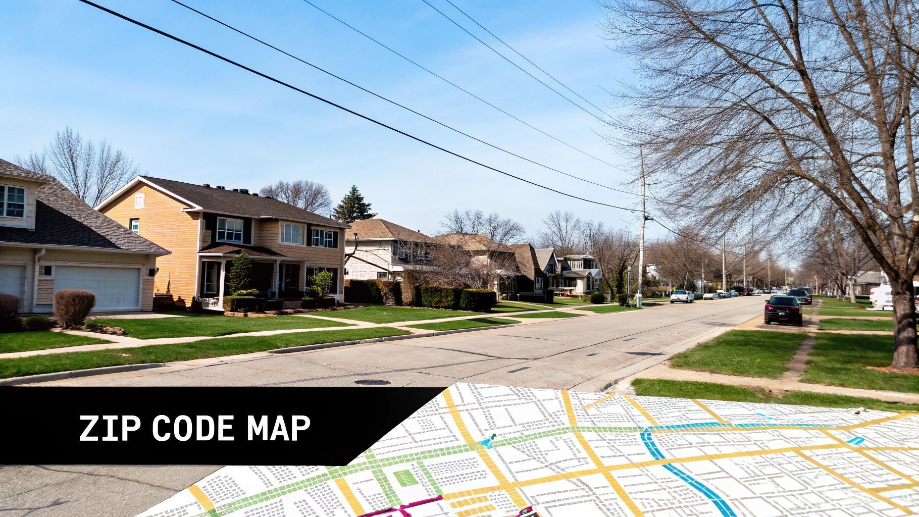
- Interactive Map of Long Island NY with ZIP Codes
Interactive Map of Long Island NY with ZIP Codes
516 Update
October 01, 2025
Trying to make sense of Long Island's postal boundaries? A good map of Long Island NY with zip codes is more than just a navigational aid—it’s an indispensable resource for anyone doing business, researching real estate, or simply exploring the area's diverse communities.
Our interactive guide is designed to give you a crystal-clear map and a sortable data table, making it easy to pinpoint exactly what you're looking for across both Nassau and Suffolk counties.
Your Essential Long Island ZIP Code Map
Getting a handle on Long Island's geography really starts with understanding its ZIP codes. The island is a true mosaic, stretching from the edge of Queens all the way out to Montauk Point. Each community has its own distinct character, and its ZIP code is often the key to unlocking information about school districts, property values, and local services.
Long Island is home to two counties and a combined population of over 7.7 million people as of 2025. The postal codes start with 11001 on the western Nassau border and go all the way up to 11980 at the island's eastern tip. This range covers everything from bustling suburban towns to quiet, rural hamlets. For a deeper dive into how these 119 distinct postal codes are laid out, this guide on Long Island ZIP codes is a great resource.
Nassau vs Suffolk County ZIP Distribution
So, how do these ZIP codes break down between the two counties? This visual gives you a quick snapshot.
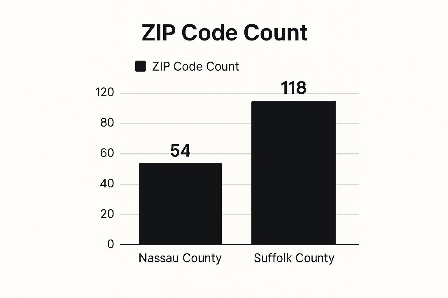
It's pretty clear from the chart that Suffolk County, with its massive land area, contains more than twice the number of ZIP codes as the more densely populated Nassau County.
A Guide to All Nassau County ZIP Codes
To really get a feel for Nassau County, you have to understand its different regions. Each area has its own character, and the ZIP codes are a big part of that story, reflecting the local geography and culture.
Our interactive map is designed for exactly this. It helps you see where the wealthy North Shore ends and the lively South Shore begins, and how they both connect to the busy central corridor. Suddenly, a simple list of numbers becomes a practical tool for anyone living on or visiting the island.
For instance, the North Shore is famous for its rolling hills and grand, old estates. ZIP codes in this area, like 11030 for Manhasset or 11542 for Glen Cove, bring to mind charming downtowns and beautiful waterfront homes along the Long Island Sound. Around here, a postal code is often shorthand for a certain lifestyle.
ZIP Codes That Define Each Region
Let's look at a few specific ZIP codes that really capture the essence of Nassau's main areas. Each one paints a picture of its town, landmarks, and unique identity.
South Shore (11561 - Long Beach): This barrier island community is instantly recognizable for its famous boardwalk and oceanfront lifestyle. The ZIP code itself is practically synonymous with summer fun and a close-knit, beach-loving vibe.
Central Nassau (11530 - Garden City): Known for its stunning cathedral, high-end shopping on Seventh Street, and classic homes, this ZIP code represents a quintessential, upscale suburban hub.
North Shore (11050 - Port Washington): Covering a peninsula steeped in maritime history, this ZIP code is all about marinas, yacht clubs, and incredible views of Manhasset Bay.
Pro Tip: By comparing these ZIP codes on our map, you'll start to see patterns in local markets and community layouts. This is a game-changer if you're exploring the local property scene.
This kind of detailed knowledge is crucial for making smart choices, whether you're thinking about moving, starting a business, or just getting to know the county better. For anyone diving into the housing market, our guide to Nassau County real estate offers a deeper look into https://516update.com/p/nassau-county-real-estate.
Exploring All Suffolk County ZIP Codes
As you head east from Nassau, you enter Suffolk County—a massive, sprawling area that truly defines Long Island's character. The county's postal codes paint a picture of incredible variety, moving from the busy commercial zones near the Nassau border all the way out to the quiet, picturesque landscapes of the North and South Forks. A good map of long island ny with zip codes isn't just helpful here; it's essential for grasping the sheer scale of the place.
To really get a handle on Suffolk, it's best to think in terms of its major townships. These large administrative areas, like Huntington or East Hampton, serve as regional anchors for the dozens of smaller villages and hamlets within them, and the ZIP codes often line up with these hyper-local communities.
Key Townships and Their Postal Codes
Sorting Suffolk's ZIP codes by township is the easiest way to make sense of the county's geography. It’s a practical approach that puts the layout into perspective and shines a light on what makes each region distinct.
Western Suffolk (e.g., Huntington, Babylon): This is where you'll find major business hubs. ZIP codes like 11747 (Melville) are synonymous with corporate parks and commercial activity, creating a densely populated zone that bridges the classic suburbia of Nassau with the more rural feel of the East End.
Central Suffolk (e.g., Brookhaven, Islip): The heart of the county is a true melting pot of residential neighborhoods and vital infrastructure. Take 11741 (Holbrook), a classic suburban community, versus 11779 (Ronkonkoma), which is known for housing Long Island MacArthur Airport.
The East End (e.g., The Hamptons, The North Fork): Out here, the geography gets really interesting. A ZIP code often represents a specific lifestyle, whether it's the glamorous beaches of 11937 (East Hampton) or the vineyards and farm stands of 11952 (Mattituck) on the North Fork.
The ZIP code 11954 (Montauk) is a perfect example of a postal code becoming shorthand for a destination. Sitting at the absolute end of the South Fork, that number instantly brings to mind the iconic lighthouse, world-class fishing, and surf-centric culture.
Try using our interactive map to trace these locations. You can visually follow the shift from Suffolk's bustling western towns to the peaceful, scenic tips of the forks. That context is what makes you truly appreciate the county's amazing diversity.
While the interactive map of Long Island NY with zip codes gives you a fantastic bird's-eye view, there are times when you just need to find specific information fast. For those moments, we've put together a comprehensive, sortable reference table right below this section.
Think of it as your go-to digital index for every postal code on the island. It's designed to help you quickly pinpoint the data you need, whether you're a business owner planning a mail campaign, a new resident getting to know your area, or just satisfying your curiosity.
How to Sort and Filter the Data
The real power of this table is its flexibility. With just a single click on any column header, you can instantly reorganize the entire list to suit your needs.
By ZIP Code: Click this header to arrange all codes in numerical order, making it simple to find a specific one you already have in mind.
By Primary City/Town: Want to find the ZIP code for a particular town? Sort this column alphabetically to jump right to it.
By County: A click here groups all the Nassau County and Suffolk County codes together, which is perfect for any regional planning or analysis.
For instance, if you sort by "Primary City/Town," you can scroll directly to "Hempstead" and instantly see that its ZIP code is 11550. It's a straightforward feature that makes this table an indispensable tool for anyone working with Long Island addresses.
Below you will find the complete, sortable list of all ZIP codes across Long Island.
Complete List of Long Island ZIP Codes
ZIP Code | Primary City/Town | County | Notable Landmark/Feature |
|---|---|---|---|
11001 | Floral Park | Nassau | Belmont Park Race Track |
11003 | Elmont | Nassau | UBS Arena |
11010 | Franklin Square | Nassau | Rath Park |
11020 | Great Neck | Nassau | Kings Point Park |
11040 | New Hyde Park | Nassau | Long Island Jewish Medical Center |
11501 | Mineola | Nassau | Nassau County Supreme Court |
11510 | Baldwin | Nassau | Baldwin Harbor Park |
11530 | Garden City | Nassau | Roosevelt Field Mall |
11542 | Glen Cove | Nassau | Webb Institute |
11550 | Hempstead | Nassau | Hofstra University |
11560 | Locust Valley | Nassau | Planting Fields Arboretum |
11561 | Long Beach | Nassau | The Long Beach Boardwalk |
11568 | Oyster Bay | Nassau | Sagamore Hill National Historic Site |
11572 | Oceanside | Nassau | Marine Nature Study Area |
11590 | Westbury | Nassau | NYCB Theatre at Westbury |
11701 | Amityville | Suffolk | The Amityville Horror House |
11706 | Babylon | Suffolk | Argyle Park |
11717 | Brentwood | Suffolk | Suffolk County Community College |
11722 | Commack | Suffolk | Hoyt Farm Town Park |
11725 | Coram | Suffolk | Pine Ridge Golf Club |
11727 | Deer Park | Suffolk | Tanger Outlets Deer Park |
11731 | East Northport | Suffolk | Northport Rural Cemetery |
11735 | Farmingdale | Nassau | Farmingdale State College |
11743 | Huntington | Suffolk | The Paramount Theater |
11746 | Huntington Station | Suffolk | Walt Whitman Shops |
11747 | Melville | Suffolk | Newsday Headquarters |
11757 | Lindenhurst | Suffolk | Lindenhurst Village Park |
11768 | Northport | Suffolk | Northport Village Park |
11772 | Patchogue | Suffolk | Patchogue Theatre for the Performing Arts |
11776 | Port Jefferson | Suffolk | Port Jefferson Ferry |
11777 | Port Jefferson Station | Suffolk | Theatre Three |
11779 | Ronkonkoma | Suffolk | Long Island MacArthur Airport (ISP) |
11787 | Smithtown | Suffolk | Caleb Smith State Park Preserve |
11791 | Stony Brook | Suffolk | Stony Brook University |
11795 | West Islip | Suffolk | Good Samaritan Hospital |
11901 | Riverhead | Suffolk | Splish Splash Water Park |
11933 | Bridgehampton | Suffolk | The Hampton Classic Horse Show |
11937 | East Hampton | Suffolk | Guild Hall |
11946 | Hampton Bays | Suffolk | Ponquogue Beach |
11951 | Manorville | Suffolk | Long Island Game Farm |
11953 | Mastic | Suffolk | Wertheim National Wildlife Refuge |
11963 | Sag Harbor | Suffolk | Sag Harbor Whaling Museum |
11968 | Southampton | Suffolk | Coopers Beach |
11976 | Water Mill | Suffolk | Parrish Art Museum |
11978 | Westhampton Beach | Suffolk | Westhampton Beach Performing Arts Center |
This table provides a solid foundation for understanding the geography of Long Island's postal codes. Use the sort functions to explore connections between towns, counties, and local landmarks.
The Long Island City Anomaly
If you're looking at a map of Long Island ZIP codes, you’ll probably notice one area that just doesn't seem to fit: Long Island City, or LIC. It's right there on the westernmost edge of the physical island, but it's a world away from the suburban towns of Nassau and Suffolk.
That's because, despite its location, LIC isn't part of either county. It's actually a neighborhood within the New York City borough of Queens. This is a critical distinction that impacts everything from local government and public services to demographics. Politically and functionally, LIC is pure New York City.
A Tale of Two Densities
Nothing highlights this urban-suburban divide better than population density. Long Island City contains some of the most densely populated ZIP codes in the entire country—a sharp contrast to the rest of the island.
This shot of the Long Island City skyline really tells the story of its vertical, urban growth.
You can see how the landscape is dominated by high-rise buildings, which is the main driver behind its incredible population density.
For instance, take a look at the numbers. The ZIP code 11109 has a mind-boggling density of nearly 149,884 people per square mile, making it one of the most concentrated urban areas in the United States. Even the larger, more mixed-use LIC ZIP code of 11101 clocks in at 12,778 people per square mile, which is still far above the New York State average. You can dig deeper into Long Island City's unique history and development on Wikipedia.
This kind of urban density shapes everything from real estate prices to the availability of local services. So, while LIC is geographically connected to Long Island, it's a completely different place in terms of lifestyle and postal organization. Getting a handle on this anomaly is the key to accurately reading any map of the region.
Putting ZIP Code Data to Work in the Real World
A great map of long island ny with zip codes isn't just for looking up addresses; it's a powerful tool for making smarter decisions. When you know how to use this data, you can get a real edge for personal planning, business strategy, and even recreation across both Nassau and Suffolk counties.
Think about it from a real estate agent's perspective. Instead of a scattergun approach, they can use the map to pinpoint ideal neighborhoods for their clients. By filtering for top-tier school districts in ZIP codes like 11753 (Jericho) or 11030 (Manhasset), they can immediately focus their search and deliver highly relevant listings. It turns a huge, time-consuming task into a precise, efficient strategy.
Local businesses can do something similar with their marketing. A new cafe in Huntington (11743) could easily identify the surrounding ZIP codes for a direct mail campaign. This ensures every dollar of their advertising budget is spent reaching people who are actually close enough to become regular customers.
Everyday Scenarios and Practical Examples
Let's dig into a few common situations to show just how useful this ZIP code data can be. Each of these examples shows how our map and sortable table can help solve real-world problems.
For Newcomers: If you're moving to Long Island, you can use ZIP codes to get a handle on school district boundaries or figure out your potential commute time to a job in Melville (11747).
For Family Historians: Someone researching their roots can take old addresses, find the corresponding ZIP codes, and zero in on ancestral hometowns. This makes it much easier to locate local historical societies, archives, or cemeteries.
For Event Organizers: A planner looking to host a large festival can analyze ZIP code demographics to find a central spot, like somewhere in or around 11590 (Westbury), that offers the easiest access for the most people.
When you start layering ZIP code boundaries with other data sets—like property values, business directories, or even flood zones—you create an incredibly insightful analytical tool. It’s the key to truly understanding the distinct character of Long Island's many communities.
This level of detail is also crucial for financial planning. If you're thinking about a move, you absolutely need to understand the economic picture of different areas. For more on that, our guide on the cost of living on Long Island provides some essential background for your research.
Frequently Asked Questions About Long Island ZIP Codes
When you're looking at a map of Long Island NY with zip codes, a few common questions tend to pop up. Whether you're a lifelong resident, a new visitor, or just doing some research, these answers should clear things up.
Distinguishing Nassau and Suffolk Codes
So, what's the deal with Nassau and Suffolk County ZIP codes? It's actually a pretty reliable system. Nassau codes generally start with 110, 115, or 118, covering the western half of the island, which is more densely populated.
Suffolk County, on the other hand, uses codes that typically begin with 117 or 119. These represent the much larger, eastern portion of the island, stretching all the way out to the Hamptons and Montauk.
Finding a Specific Town ZIP Code
Need to find the ZIP code for a particular town? The fastest way is to use our sortable Quick Reference Table. Just click the header for the "Primary City/Town" column to sort it alphabetically. You'll find the town and its ZIP code in seconds.
It's interesting to note that a ZIP code is more than just a mailing address; it often reflects an area's economic standing. You can dive deeper into this relationship in our guide to the Long Island median income.
Are Brooklyn and Queens Included?
This is a classic Long Island question. Geographically, yes, Brooklyn and Queens are on the landmass of Long Island. But when it comes to postal service and general administration, they are boroughs of New York City with their own set of ZIP codes. Our map and guide stick to what everyone colloquially calls "Long Island"—Nassau and Suffolk counties.
For the latest news and community updates across Nassau County, trust 516 Update to keep you informed. Visit us at https://516update.com.